Elias M. Costa
Elias M. Costa
Início
Postagens
Vídeos
Projetos
Paletras e Workshops
Publicações
Contato
Cursos
Lattes
Light
Dark
Automatic
2
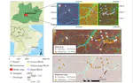
Use of Airborne Radar Images and Machine Learning Algorithms to Map Soil Clay, Silt, and Sand Contents in Remote Areas under the Amazon Rainforest
Digital soil mapping; soil texture; radar P-band; reference area; soil survey
Ana Carolina de S. Ferreira
,
Marcos Bacis Ceddia
,
Elias Mendes Costa
,
Érika F. M. Pinheiro
,
Mariana Melo do Nascimento
,
Gustavo M. Vasques
PDF
Citação
Projeto
Pôster
DOI
Training pedologist for soil mapping-Contextualizing methods and its accuracy using the project pedagogy approach
The PPA demonstrates relevance in the teaching-learning process of soil mapping. Combination of data-driven and expert knowledge methods are advised for future courses. Soil mapping using new tools involves multidisciplinary knowledge. This course can serve as a guide to meet the needs of PronaSolos
Elias Mendes Costa
,
Marcos Bacis Ceddia
,
Felipe Nascimento dos Santos
,
Laiz de Oliveira Silva
,
Igor Prata Terra de Rezende
,
Douglath Alves Correa Fernandes
PDF
Citação
Projeto
Pôster
DOI
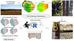
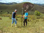
Mapping soil properties in a poorly-accessible area
DSM tools are useful for soil sampling and mapping in areas with limited access. Non-linear models are more effective to map soil properties than linear models. GAM_scorpan model can improve soil properties predictions. GAM smooth functions can successfully map soil properties in 3-D. The high functionality of 2-D and 3-D maps benefits decision-makers.
Elias Mendes Costa
,
Helena Saraiva Koenow Pinheiro
,
Lúcia Helena Cunha dos Anjos
,
Robson Altiellys Tosta Marcondes
,
Yuri Andrei Gelsleichter
PDF
Citação
Projeto
DOI
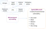
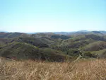
Spatial Bayesian belief networks a a participatory approach for mapping environmental vulnerability at the Itatiaia National Park, Brazil
The objective of this work was to use information on soils, land use/cover, climate, relief and parent material to create a BBN for analysing environmental vulnerability.
Elias Mendes Costa
,
Lúcia Helena Cunha dos Anjos
,
Helena Saraiva Koenow Pinheiro
,
Yuri Andrei Gelsleichter
,
Robson Altiellys Tosta Marcondes
PDF
Citação
Projeto
Vídeo
DOI
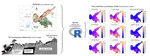
Digital elevation model quality on digital soil mapping prediction accuracy
The study was developed by Elias Mendes Costa, Alessandro Samuel-Rosa, and Lúcia Helena Cunha dos Anjos as part of the Master Thesis of Elias Mendes Costa presented before the Post-Graduate Course in Agronomy-Soil Science of the Federal Rural University of Rio de Janeiro on 26 February 2015.
Elias Mendes Costa
,
Alessandro Samuel Rosa
,
Lúcia Helena Cunha dos Anjos
PDF
Citação
Código
Dados
Projeto
DOI
Mapping soil organic carbon and organic matter fractions by Geographically Weighted Regression
The study was developed by Elias Mendes Costa, Wagner de Souza Tassinari, Helena Saraiva Koenow Pinheiro, Sidinei Julio Beutler and Lúcia Helena Cunha dos Anjos as part of the Master Thesis of Elias Mendes Costa presented before the technical course in statistics at Federal Rural University of Rio de Janeiro on July 2017.
Elias Mendes Costa
,
Wagner de Souza Tassinari
,
Helena Saraiva Koenow Pinheiro
,
Sidinei Julio Beutler
,
Lúcia Helena Cunha dos Anjos
PDF
Citação
Projeto
DOI
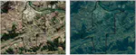
RapidEye image processing for soil use mapping in rugged landscape accuracy
The objective of this work was to analyse RapidEye satellite image characteristics, as well as to assess its orthorectification geometric accuracy and its application for land use mapping, in a rugged landscape.
Elias Mendes Costa
,
Mauro Antonio Homem Antunes
,
Paula Debiasi
,
Lúcia Helena Cunha dos Anjos
PDF
Citação
Código
Dados
Projeto
DOI
Citação
×